
Make a donation
Gear up for your next adventure:
As an Amazon Associate, this site earns from qualifying purchases at no extra cost to you.
Bruce Township topographic map
Click on the map to display elevation.
Make a donation
Gear up for your next adventure:
As an Amazon Associate, this site earns from qualifying purchases at no extra cost to you.
About this map
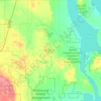
Name: Bruce Township topographic map, elevation, terrain.
Location: Bruce Township, Chippewa County, Michigan, United States (46.23125 -84.38520 46.41986 -84.18040)
Average elevation: 197 m
Minimum elevation: 173 m
Maximum elevation: 252 m
Make a donation
Gear up for your next adventure:
As an Amazon Associate, this site earns from qualifying purchases at no extra cost to you.
Other topographic maps
Click on a map to view its topography, its elevation and its terrain.
Mcnearney Lake
United States > Michigan > Chippewa County > Bay Mills Township
Average elevation: 286 m
Hulbert
United States > Michigan > Chippewa County > Hulbert Township
Hulbert is a rural community in western Chippewa County in the Upper Peninsula. The community is located within Hulbert Township about 40 miles (64 km) south of the Tahquamenon Falls. The community sits at an elevation of 751 feet (229 m) above sea level.
Average elevation: 231 m
Whitefish Point
United States > Michigan > Chippewa County > Whitefish Township
Average elevation: 179 m
Make a donation
Gear up for your next adventure:
As an Amazon Associate, this site earns from qualifying purchases at no extra cost to you.
Make a donation
Gear up for your next adventure:
As an Amazon Associate, this site earns from qualifying purchases at no extra cost to you.
Make a donation
Gear up for your next adventure:
As an Amazon Associate, this site earns from qualifying purchases at no extra cost to you.