Geolocate

Atchison topographic map

Click on the map to display elevation.

About this map

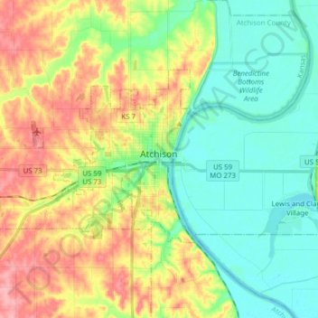
Name: Atchison topographic map, elevation, terrain.

Location: Atchison, Atchison County, Kansas, United States (39.52780 -95.25129 39.59476 -95.09746)

Average elevation: 274 m

Minimum elevation: 234 m

Maximum elevation: 337 m

Other topographic maps

Click on a map to view its topography, its elevation and its terrain.

Shannon

United States > Kansas > Atchison County

Average elevation: 330 m

Cummings

United States > Kansas > Atchison County

Average elevation: 316 m

Gear up for your next adventure:

👟Lightweight Trail Runners - Agile footwear for fast movement over rugged Australian terrain
🩹Wilderness First Aid Kits - Comprehensive medical kits tailored for hiking and remote exploration
🧴Sunscreen SPF - Sun protection for outdoor activities
📍Handheld GPS - GPS devices for hiking and navigation
🧊Insulated Stainless Steel Flasks - Keep water cold for 24 hours in the heat or coffee hot in the cold

As an Amazon Associate, this site earns from qualifying purchases at no extra cost to you.