
Chinatown topographic map
Interactive map
Click on the map to display elevation.
About this map
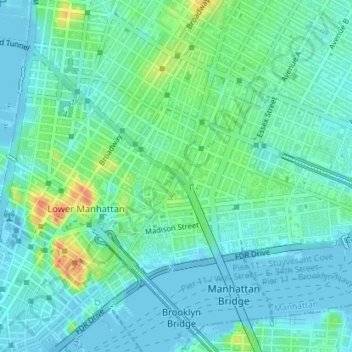
Name: Chinatown topographic map, elevation, terrain.
Average elevation: 12 m
Minimum elevation: -7 m
Maximum elevation: 47 m
Other topographic maps
Click on a map to view its topography, its elevation and its terrain.
Harlem
USA > New York > New York City
Harlem, Manhattan, Manhattan Community Board 10, New York County, New York City, New York, USA
Average elevation: 16 m
Rikers Island
USA > New York > New York City
Rikers Island, Bronx County, New York City, New York, USA
Average elevation: 2 m
Governors Island
USA > New York > New York City
Governors Island, Manhattan Community Board 1, New York County, New York City, New York, USA
Average elevation: 1 m