
Quorn topographic map
Interactive map
Click on the map to display elevation.
About this map
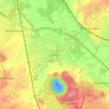
Name: Quorn topographic map, elevation, terrain.
Average elevation: 55 m
Minimum elevation: -59 m
Maximum elevation: 102 m
Other topographic maps
Click on a map to view its topography, its elevation and its terrain.
Loughborough
United Kingdom > England > Leicestershire > Charnwood
Loughborough, Charnwood, Leicestershire, England, LE11 5BJ, United Kingdom
Average elevation: 61 m
Shepshed
United Kingdom > England > Leicestershire > Charnwood
Shepshed, Charnwood, Leicestershire, East Midlands, England, United Kingdom
Average elevation: 111 m