
Municipio de Juárez topographic map
Interactive map
Click on the map to display elevation.
About this map
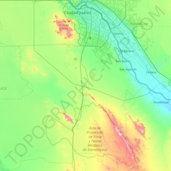
Name: Municipio de Juárez topographic map, elevation, terrain.
Location: Municipio de Juárez, Chihuahua, Mexique (31.11996 -106.95163 31.78390 -106.18088)
Average elevation: 1,249 m
Minimum elevation: 1,085 m
Maximum elevation: 1,795 m
Other topographic maps
Click on a map to view its topography, its elevation and its terrain.
Los Leones
Los Leones, Aldama, Chihuahua, Mexique
Average elevation: 1,329 m
La Ventana
La Ventana, Urique, Chihuahua, Mexique
Average elevation: 1,191 m
Ciudad Juárez
Mexique > Chihuahua > Municipio de Juárez
Ciudad Juárez, Municipio de Juárez, Chihuahua, 32390, Mexique
Average elevation: 1,218 m
La Manga
Mexique > Chihuahua > Temósachic
La Manga, Temósachic, Chihuahua, Mexique
Average elevation: 1,939 m
Los Hornitos
Mexique > Chihuahua > Los Hornitos
Los Hornitos, Riva Palacio, Chihuahua, Mexique
Average elevation: 1,828 m