
Listowel Municipal District topographic map
Interactive map
Click on the map to display elevation.
About this map
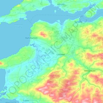
Name: Listowel Municipal District topographic map, elevation, terrain.
Location: Listowel Municipal District, County Kerry, Munster, Ireland (52.31404 -9.94794 52.60245 -9.29747)
Average elevation: 67 m
Minimum elevation: -2 m
Maximum elevation: 367 m
Other topographic maps
Click on a map to view its topography, its elevation and its terrain.
Mangerton
Mangerton Mountain's height and topographic prominence, qualifies it to meet the British Isles Marilyn classification, as well as the Arderin, Simm and Hewitt classifications. Mangerton Mountain ranks as the 10th-highest mountain in Ireland on the MountainViews Online Database, 100 Highest Irish Mountains,…
Average elevation: 657 m