
Elk Island topographic map
Interactive map
Click on the map to display elevation.
About this map
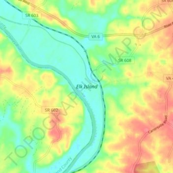
Name: Elk Island topographic map, elevation, terrain.
Location: Elk Island, Goochland County, Virginia, VS (37.68587 -78.13940 37.74235 -78.08558)
Average elevation: 79 m
Minimum elevation: 50 m
Maximum elevation: 114 m
Other topographic maps
Click on a map to view its topography, its elevation and its terrain.
Greenfields
VS > Virginia > Greenfields
Greenfields, Albemarle County, Virginia, 22908, VS
Average elevation: 136 m
Valley Oaks
VS > Virginia > Valley Oaks
Valley Oaks, Hanover County, Virginia, VS
Average elevation: 50 m
Richmond City
VS > Virginia > Richmond City
Richmond, Richmond City, Virginia, 23298, VS
Average elevation: 53 m