
Posccota topographic map
Interactive map
Click on the map to display elevation.
About this map
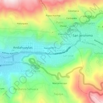
Name: Posccota topographic map, elevation, terrain.
Location: Posccota, Andahuaylas, Apurímac, 03701, Perú (-13.67805 -73.39841 -13.63805 -73.35841)
Average elevation: 3,088 m
Minimum elevation: 2,864 m
Maximum elevation: 3,463 m
Other topographic maps
Click on a map to view its topography, its elevation and its terrain.
Sucaraylla
Perú > Apurímac > Andahuaylas
Sucaraylla, Andahuaylas, Apurímac, Perú
Average elevation: 3,631 m
Andahuaylas
Perú > Apurímac > Andahuaylas
Andahuaylas, Apurímac, 03701, Perú
Average elevation: 3,818 m
Chasquitambo
Perú > Apurímac > Andahuaylas > Santa Rosa de Chacapuente
Chasquitambo, Santa Rosa de Chacapuente, Andahuaylas, Apurímac, Perú
Average elevation: 3,805 m