
Make a donation
Gear up for your next adventure:
As an Amazon Associate, this site earns from qualifying purchases at no extra cost to you.
Charakas topographic map
Click on the map to display elevation.
Make a donation
Gear up for your next adventure:
As an Amazon Associate, this site earns from qualifying purchases at no extra cost to you.
Charakas
The community of Charakas (Δημοτική Κοινότητα Χάρακος) consists of the village Charakas and the smaller villages Agia Fotia (Αγιά Φωτιά) (pop. 22, at elevation 275 m, 2 km to the West from Charakas) and Doraki (Δωράκι) (pop. 24, at elevation 310 m, 1.5 km to the East from Charakas).
Make a donation
Gear up for your next adventure:
As an Amazon Associate, this site earns from qualifying purchases at no extra cost to you.
About this map
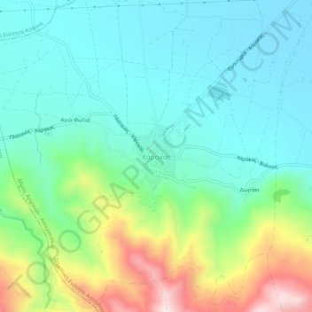
Name: Charakas topographic map, elevation, terrain.
Average elevation: 357 m
Minimum elevation: 220 m
Maximum elevation: 721 m
Make a donation
Gear up for your next adventure:
As an Amazon Associate, this site earns from qualifying purchases at no extra cost to you.