
Make a donation
Gear up for your next adventure:
As an Amazon Associate, this site earns from qualifying purchases at no extra cost to you.
Avon topographic map
Click on the map to display elevation.
Make a donation
Gear up for your next adventure:
As an Amazon Associate, this site earns from qualifying purchases at no extra cost to you.
About this map
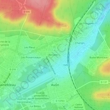
Name: Avon topographic map, elevation, terrain.
Average elevation: 88 m
Minimum elevation: 49 m
Maximum elevation: 154 m
Make a donation
Gear up for your next adventure:
As an Amazon Associate, this site earns from qualifying purchases at no extra cost to you.
Other topographic maps
Click on a map to view its topography, its elevation and its terrain.
Parc de l'Abbaye du Lys
France > Ile-de-France > Seine-et-Marne > Dammarie-les-Lys
Average elevation: 66 m
Make a donation
Gear up for your next adventure:
As an Amazon Associate, this site earns from qualifying purchases at no extra cost to you.
Mazagran
France > Ile-de-France > Seine-et-Marne > Saint-Denis-lès-Rebais > Mazagran
Average elevation: 148 m