
Make a donation
Gear up for your next adventure:
As an Amazon Associate, this site earns from qualifying purchases at no extra cost to you.
Kauai topographic map
Click on the map to display elevation.
Make a donation
Gear up for your next adventure:
As an Amazon Associate, this site earns from qualifying purchases at no extra cost to you.
Kauai
Kauaʻi's climate is tropical, with generally humid and stable conditions year-round, although infrequent storms cause severe flooding. At the lower elevations, the annual precipitation varies from an average of about 50 in (130 cm) on the windward (northeastern) shore to less than 20 in (51 cm) on the (southwestern) leeward side of the island. The average temperature in Lihu'e, the county seat, ranges from 78 °F (26 °C) in February to 85 °F (29 °C) in August and September.
Make a donation
Gear up for your next adventure:
As an Amazon Associate, this site earns from qualifying purchases at no extra cost to you.
About this map
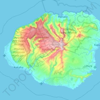
Name: Kauai topographic map, elevation, terrain.
Location: Kauai, Kauaʻi County, Hawaii, United States (21.86822 -159.78796 22.23271 -159.29232)
Average elevation: 216 m
Minimum elevation: 0 m
Maximum elevation: 1,568 m
Make a donation
Gear up for your next adventure:
As an Amazon Associate, this site earns from qualifying purchases at no extra cost to you.
Other topographic maps
Click on a map to view its topography, its elevation and its terrain.
Make a donation
Gear up for your next adventure:
As an Amazon Associate, this site earns from qualifying purchases at no extra cost to you.
Make a donation
Gear up for your next adventure:
As an Amazon Associate, this site earns from qualifying purchases at no extra cost to you.
Make a donation
Gear up for your next adventure:
As an Amazon Associate, this site earns from qualifying purchases at no extra cost to you.
Make a donation
Gear up for your next adventure:
As an Amazon Associate, this site earns from qualifying purchases at no extra cost to you.