
Make a donation
Gear up for your next adventure:
As an Amazon Associate, this site earns from qualifying purchases at no extra cost to you.
Cobham topographic map
Click on the map to display elevation.
Make a donation
Gear up for your next adventure:
As an Amazon Associate, this site earns from qualifying purchases at no extra cost to you.
Cobham
The River Mole runs through Cobham, with a visitor area and well-surfaced path by the mill in the High Street, dividing the low-rise urban village/town centre from the remaining agricultural parts of Cobham in the west and south. This can flood small, old parts of the village centre in extreme rainfall. Elevation reaches a minimum here of 20 metres (66 ft) above sea level.[16][17]
Make a donation
Gear up for your next adventure:
As an Amazon Associate, this site earns from qualifying purchases at no extra cost to you.
About this map
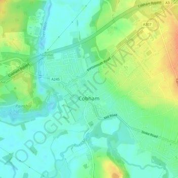
Name: Cobham topographic map, elevation, terrain.
Location: Cobham, Elmbridge, Surrey, England, United Kingdom (51.32439 -0.42790 51.33843 -0.39933)
Average elevation: 28 m
Minimum elevation: 14 m
Maximum elevation: 51 m
Make a donation
Gear up for your next adventure:
As an Amazon Associate, this site earns from qualifying purchases at no extra cost to you.
Other topographic maps
Click on a map to view its topography, its elevation and its terrain.
Esher
United Kingdom > England > Surrey > Elmbridge
Esher is an outlying suburb of London near the London-Surrey Border, and with Esher Commons at its southern end, the town marks one limit of the Greater London Built-Up Area. Esher has a linear commercial high street and is otherwise suburban in density, with varying elevations, few high rise buildings and…
Average elevation: 27 m