
Port Philip topographic map
Interactive map
Click on the map to display elevation.
About this map
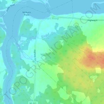
Name: Port Philip topographic map, elevation, terrain.
Average elevation: 12 m
Minimum elevation: -1 m
Maximum elevation: 45 m
Other topographic maps
Click on a map to view its topography, its elevation and its terrain.
Hastings
Canada > Nova Scotia > Municipality of the County of Cumberland
Hastings, Municipality of the County of Cumberland, Cumberland County, Nova Scotia, B4H 3Y3, Canada
Average elevation: 63 m
Brookdale
Canada > Nova Scotia > Municipality of the County of Cumberland
Brookdale, Municipality of the County of Cumberland, Cumberland County, Nova Scotia, B4H 3Y3, Canada
Average elevation: 52 m
Hansford
Canada > Nova Scotia > Municipality of the County of Cumberland
Hansford, Municipality of the County of Cumberland, Cumberland County, Nova Scotia, B0M 1P0, Canada
Average elevation: 54 m
Southampton
Canada > Nova Scotia > Municipality of the County of Cumberland
Southampton, Municipality of the County of Cumberland, Cumberland County, Nova Scotia, B0M 1W0, Canada
Average elevation: 78 m
Muddy Plains
Canada > Nova Scotia > Municipality of the County of Cumberland > Shulie
Muddy Plains, Shulie, Municipality of the County of Cumberland, Cumberland County, Nova Scotia, B0L 1A0, Canada
Average elevation: 125 m