Geolocate

Manvel topographic map

Click on the map to display elevation.

About this map

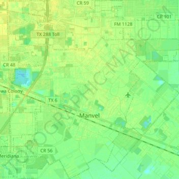
Name: Manvel topographic map, elevation, terrain.

Location: Manvel, Brazoria County, Texas, 77578, United States (29.42547 -95.41707 29.54148 -95.31608)

Average elevation: 17 m

Minimum elevation: 9 m

Maximum elevation: 22 m

Other topographic maps

Click on a map to view its topography, its elevation and its terrain.

Damon Mound

United States > Texas > Brazoria County > Damon

Average elevation: 28 m

Damon

United States > Texas > Brazoria County

Average elevation: 25 m

Damon

United States > Texas > Brazoria County

Average elevation: 25 m

Meridiana

United States > Texas > Brazoria County > Iowa Colony

Average elevation: 16 m

Rosharon

United States > Texas > Brazoria County

Average elevation: 16 m

Gear up for your next adventure:

📣High-Decibel Survival Whistles - Signaling tool for rescue that carries much further than a human voice
🔥Camping Stoves - Portable stoves for outdoor cooking
🪢Paracord - Multi-purpose survival cord
📖Australian Bush Survival Books - Local knowledge on finding water and surviving the outback
🖼️Scratch-off Australia Map - Track the regions and peaks you have explored geographically

As an Amazon Associate, this site earns from qualifying purchases at no extra cost to you.