
Wildenthal topographic map
Interactive map
Click on the map to display elevation.
About this map
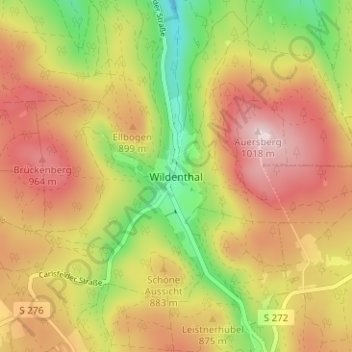
Name: Wildenthal topographic map, elevation, terrain.
Average elevation: 855 m
Minimum elevation: 669 m
Maximum elevation: 1,015 m
Other topographic maps
Click on a map to view its topography, its elevation and its terrain.
Wolfsgrün
Deutschland > Sachsen > Erzgebirgskreis > Eibenstock
Wolfsgrün, Blauenthal, Eibenstock, Erzgebirgskreis, Sachsen, 08309, Deutschland
Average elevation: 568 m
Eibenstock
Deutschland > Sachsen > Erzgebirgskreis > Eibenstock
Eibenstock, Erzgebirgskreis, Sachsen, 08309, Deutschland
Average elevation: 751 m
Carlsfeld
Deutschland > Sachsen > Erzgebirgskreis > Eibenstock
Carlsfeld, Eibenstock, Erzgebirgskreis, Sachsen, 08309, Deutschland
Average elevation: 891 m