
Thank you for supporting this site ❤️
Make a donation
Make a donation
Gear up for your next adventure:
As an Amazon Associate, this site earns from qualifying purchases at no extra cost to you.
Ebudi topographic map
Click on the map to display elevation.
Thank you for supporting this site ❤️
Make a donation
Make a donation
Gear up for your next adventure:
As an Amazon Associate, this site earns from qualifying purchases at no extra cost to you.
About this map
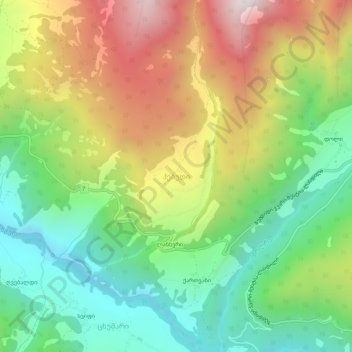
Name: Ebudi topographic map, elevation, terrain.
Location: Ebudi, Mestia Municipality, Samegrelo-Upper Svaneti, Georgia (43.00834 42.53369 43.04834 42.57369)
Average elevation: 1,524 m
Minimum elevation: 1,079 m
Maximum elevation: 2,163 m
Thank you for supporting this site ❤️
Make a donation
Make a donation
Gear up for your next adventure:
As an Amazon Associate, this site earns from qualifying purchases at no extra cost to you.