
Make a donation
Gear up for your next adventure:
As an Amazon Associate, this site earns from qualifying purchases at no extra cost to you.
Morlanwelz topographic map
Click on the map to display elevation.
Make a donation
Gear up for your next adventure:
As an Amazon Associate, this site earns from qualifying purchases at no extra cost to you.
About this map
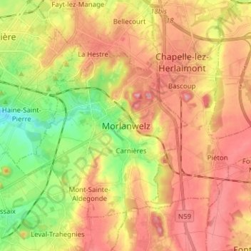
Name: Morlanwelz topographic map, elevation, terrain.
Location: Morlanwelz, La Louvière, Hainaut, Wallonie, 7141, Belgique (50.41098 4.21236 50.49098 4.29236)
Average elevation: 143 m
Minimum elevation: 70 m
Maximum elevation: 204 m
Make a donation
Gear up for your next adventure:
As an Amazon Associate, this site earns from qualifying purchases at no extra cost to you.
Other topographic maps
Click on a map to view its topography, its elevation and its terrain.
Make a donation
Gear up for your next adventure:
As an Amazon Associate, this site earns from qualifying purchases at no extra cost to you.
Bois Saint-Julien
Belgique > Hainaut > La Louvière > Strépy-Bracquegnies > Les Hubert
Average elevation: 71 m