
Make a donation
Gear up for your next adventure:
As an Amazon Associate, this site earns from qualifying purchases at no extra cost to you.
Motten topographic map
Click on the map to display elevation.
Make a donation
Gear up for your next adventure:
As an Amazon Associate, this site earns from qualifying purchases at no extra cost to you.
About this map
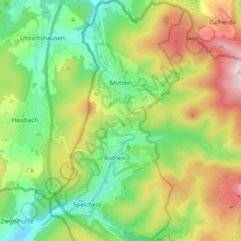
Name: Motten topographic map, elevation, terrain.
Location: Motten, Landkreis Bad Kissingen, Bayern, 97786, Deutschland (50.34163 9.73300 50.42580 9.80685)
Average elevation: 510 m
Minimum elevation: 327 m
Maximum elevation: 836 m
Make a donation
Gear up for your next adventure:
As an Amazon Associate, this site earns from qualifying purchases at no extra cost to you.
Other topographic maps
Click on a map to view its topography, its elevation and its terrain.
Make a donation
Gear up for your next adventure:
As an Amazon Associate, this site earns from qualifying purchases at no extra cost to you.
Make a donation
Gear up for your next adventure:
As an Amazon Associate, this site earns from qualifying purchases at no extra cost to you.
Make a donation
Gear up for your next adventure:
As an Amazon Associate, this site earns from qualifying purchases at no extra cost to you.
Pilsterköpfe
Deutschland > Bayern > Landkreis Bad Kissingen > Oberleichtersbach
Average elevation: 490 m
Make a donation
Gear up for your next adventure:
As an Amazon Associate, this site earns from qualifying purchases at no extra cost to you.
Make a donation
Gear up for your next adventure:
As an Amazon Associate, this site earns from qualifying purchases at no extra cost to you.
Schwarze Berge
Deutschland > Bayern > Landkreis Bad Kissingen > Riedenberg
Feuerbachmoor | Grundwiese (Hornwiese) | Haarberg | Kernzonen im bayerischen Teil des Biosphärenreservats Rhön | Naturwaldinsel Buchwald | Naturwaldreservat Dachsbau | Naturwaldreservat Dianensruh | Reiterswiesener Höhe-Häuserlohwäldchen | Schachblumenwiesen bei Zeitlofs | Schwarze Berge | Sodenberg-Gans…
Average elevation: 575 m
Make a donation
Gear up for your next adventure:
As an Amazon Associate, this site earns from qualifying purchases at no extra cost to you.
Wermerichshausen
Deutschland > Bayern > Landkreis Bad Kissingen > Münnerstadt
Average elevation: 312 m
Staatsbad Brückenau
Deutschland > Bayern > Landkreis Bad Kissingen > Bad Brückenau
Average elevation: 403 m
Make a donation
Gear up for your next adventure:
As an Amazon Associate, this site earns from qualifying purchases at no extra cost to you.
Dammersfeldkuppe
Deutschland > Bayern > Landkreis Bad Kissingen > Wildflecken
Average elevation: 781 m
Make a donation
Gear up for your next adventure:
As an Amazon Associate, this site earns from qualifying purchases at no extra cost to you.
Bad Kissingen
Deutschland > Bayern > Landkreis Bad Kissingen > Bad Kissingen > Bad Kissingen
Es kamen nach dem Ersten Weltkrieg sogar mehr Kurgäste als zuvor, aber andere; aus einer neuen sozialen Mittelschicht, wie Politiker, Bankiers, Beamte, höhere Angestellte und Privatiers. Dadurch stieg die Zahl der Kurgäste auf einen neuen Höchststand von 36.486 im Jahr 1922.
Average elevation: 295 m
Detter
Deutschland > Bayern > Landkreis Bad Kissingen
Das Dorf liegt im Naturpark Bayerische Rhön nahe dem Tal der Schondra. Das Gemeindegebiet von Zeitlofs ist Teil der Hügellandschaft der südlichen Rhön mit einer Höhe von 242 bis 477 Meter über NN. Detter liegt im Südosten des Gemeindegebietes. Der Detterbach fließt in unmittelbarer Nähe des Orts.
Average elevation: 400 m
Heckmühle
Deutschland > Bayern > Landkreis Bad Kissingen > Wartmannsroth > Heckmühle
Average elevation: 370 m
Make a donation
Gear up for your next adventure:
As an Amazon Associate, this site earns from qualifying purchases at no extra cost to you.
Stangenroth
Deutschland > Bayern > Landkreis Bad Kissingen > Burkardroth > Stangenroth
Average elevation: 407 m
Münnerstadt
Deutschland > Bayern > Landkreis Bad Kissingen > Münnerstadt > Münnerstadt
Average elevation: 311 m
Make a donation
Gear up for your next adventure:
As an Amazon Associate, this site earns from qualifying purchases at no extra cost to you.
Maria Bildhausen
Deutschland > Bayern > Landkreis Bad Kissingen > Münnerstadt > Maria Bildhausen
Average elevation: 340 m
Make a donation
Gear up for your next adventure:
As an Amazon Associate, this site earns from qualifying purchases at no extra cost to you.