
Town of East Hampton topographic map
Interactive map
Click on the map to display elevation.
Town of East Hampton
East Hampton is regularly hit by hurricanes and Nor'easters. Given the town's generally flat topography, water often accumulates on town roads stranding motorists in heavy rains.
About this map
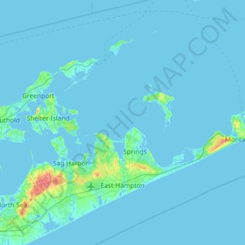
Name: Town of East Hampton topographic map, elevation, terrain.
Average elevation: 3 m
Minimum elevation: -4 m
Maximum elevation: 81 m
Other topographic maps
Click on a map to view its topography, its elevation and its terrain.
Hampton Park
United States > New York > Suffolk County > North Sea > Town of Southampton
Average elevation: 17 m
Squiretown
United States > New York > Suffolk County > Hampton Bays > Town of Southampton
Average elevation: 13 m
East Hampton
United States > New York > Suffolk County > East Hampton > Village of East Hampton
Average elevation: 12 m
Pine Neck
United States > New York > Suffolk County > East Quogue > Town of Southampton
Average elevation: 4 m
Montauk Station
United States > New York > Suffolk County > Town of East Hampton > Montauk > Montauk Station
Average elevation: 11 m
Centerport
United States > New York > Suffolk County > Huntington > Centerport
Average elevation: 44 m
Battery Barlow (historical)
United States > New York > Suffolk County > Fishers Island > Fishers Island
Average elevation: 1 m
Jayne's Hill
United States > New York > Suffolk County > Town of Huntington
Jayne's Hill (also known as High Hill, West Hills, Oakley's Hill, and Janes Hill) is the highest point on Long Island, New York, with an elevation of between 387 feet (118 m) and 400.9 feet (122.2 m) above sea level. It is situated on the Harbor Hill moraine, a terminal moraine that makes up the northern spine…
Average elevation: 73 m
Jericho
United States > New York > Suffolk County > East Hampton > Village of East Hampton > Jericho
Average elevation: 9 m