
Make a donation
Gear up for your next adventure:
As an Amazon Associate, this site earns from qualifying purchases at no extra cost to you.
Monte Cinto topographic map
Click on the map to display elevation.
Make a donation
Gear up for your next adventure:
As an Amazon Associate, this site earns from qualifying purchases at no extra cost to you.
Monte Cinto
The elevation of the mountain is 2,706 metres (8,878 ft) and so is its prominence, making it one of the most prominent peaks in Europe. It is the highest peak of the Monte Cinto massif, one of the four main massifs in Corsica.
Make a donation
Gear up for your next adventure:
As an Amazon Associate, this site earns from qualifying purchases at no extra cost to you.
About this map
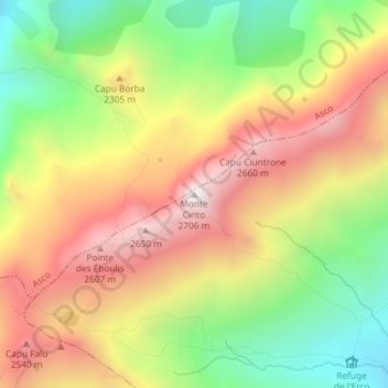
Name: Monte Cinto topographic map, elevation, terrain.
Average elevation: 2,151 m
Minimum elevation: 1,623 m
Maximum elevation: 2,687 m
Make a donation
Gear up for your next adventure:
As an Amazon Associate, this site earns from qualifying purchases at no extra cost to you.