Geolocate

Swanpool topographic map

Click on the map to display elevation.

About this map

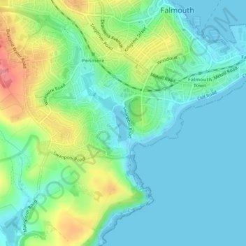
Name: Swanpool topographic map, elevation, terrain.

Location: Swanpool, Falmouth, Cornwall, England, United Kingdom (50.14092 -5.07965 50.14476 -5.07700)

Average elevation: 25 m

Minimum elevation: -1 m

Maximum elevation: 86 m

Other topographic maps

Click on a map to view its topography, its elevation and its terrain.

Pendennis Point

United Kingdom > England > Cornwall > Falmouth

Average elevation: 2 m

Lower Kergilliack

United Kingdom > England > Cornwall > Falmouth

Average elevation: 65 m

Gear up for your next adventure:

🧳Outdoor Travel Organizers - Gear organization accessories
🎒Tactical Waist Packs - Quick access to your compass, phone, and snacks while walking
🔋Rechargeable Batteries - Eco-friendly power for high-drain GPS units and flashlights
📖Australian Bush Survival Books - Local knowledge on finding water and surviving the outback
👖Convertible Hiking Trousers - Zip-off legs to adapt to changing temperatures throughout the day

As an Amazon Associate, this site earns from qualifying purchases at no extra cost to you.