
Make a donation
Gear up for your next adventure:
As an Amazon Associate, this site earns from qualifying purchases at no extra cost to you.
Mount Everett topographic map
Click on the map to display elevation.
Make a donation
Gear up for your next adventure:
As an Amazon Associate, this site earns from qualifying purchases at no extra cost to you.
Mount Everett
Mount Everett helps divide the watersheds of the Hudson and Housatonic rivers. Its eastern slopes share a larger escarpment with Mount Race and Bear Mountain plus several related summits. This escarpment rises from an elevation around 700 feet in Sheffield's Housatonic Valley at a mean angle of about 20 degrees, although its higher reaches are markedly steeper. Everett's more gentle, western slopes begin in a valley occupied by the township of Mount Washington, where elevations average about 1,700 feet.
Make a donation
Gear up for your next adventure:
As an Amazon Associate, this site earns from qualifying purchases at no extra cost to you.
About this map
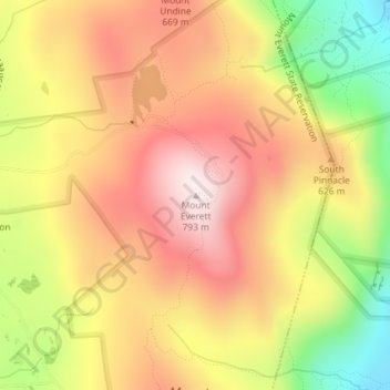
Name: Mount Everett topographic map, elevation, terrain.
Average elevation: 561 m
Minimum elevation: 263 m
Maximum elevation: 783 m
Make a donation
Gear up for your next adventure:
As an Amazon Associate, this site earns from qualifying purchases at no extra cost to you.
Other topographic maps
Click on a map to view its topography, its elevation and its terrain.
Adams
United States > Massachusetts > Berkshire County
According to the United States Census Bureau, the town has a total area of 23.0 square miles (59.5 km2), of which 22.9 square miles (59.3 km2) is land and 0.077 square miles (0.2 km2), or 0.33%, is water. The town lies along the valley surrounding the Hoosic River and its tributary brooks. Set between the…
Average elevation: 481 m
Pittsfield
United States > Massachusetts > Berkshire County
Pittsfield has a humid continental climate (Dfb). Winters are harsh due the city's high elevation at 1,039 ft (317 m), with an average annual snowfall of 75.9 inches (1,930 mm) and temperatures dipping to 0 °F (−18 °C) or colder 13 times per year. Summers, however, are typically warm and pleasant, with…
Average elevation: 369 m
Make a donation
Gear up for your next adventure:
As an Amazon Associate, this site earns from qualifying purchases at no extra cost to you.
Mount Washington
United States > Massachusetts > Berkshire County
Mount Washington is located on a plateau in the Taconic Mountains. To the east, Mount Everett, the highest point in town and the highest point in the southern Taconic Mountains, rises 2,602 feet (793 m) near the town's eastern border. To the north, several mountains and hills lie along the Egremont town line.…
Average elevation: 400 m
Make a donation
Gear up for your next adventure:
As an Amazon Associate, this site earns from qualifying purchases at no extra cost to you.
Make a donation
Gear up for your next adventure:
As an Amazon Associate, this site earns from qualifying purchases at no extra cost to you.
Make a donation
Gear up for your next adventure:
As an Amazon Associate, this site earns from qualifying purchases at no extra cost to you.
Peru
United States > Massachusetts > Berkshire County
Peru has the highest mean altitude in Massachusetts and, along with neighboring Windsor, is one of only two municipalities with a mean elevation above 2,000 feet. It lies on high ground in the Berkshire Hills, with three main peaks in the town. Much of Peru is forested, with a large portion of the northern…
Average elevation: 528 m
Make a donation
Gear up for your next adventure:
As an Amazon Associate, this site earns from qualifying purchases at no extra cost to you.
Pittsfield
United States > Massachusetts > Berkshire County
Pittsfield has a humid continental climate (Dfb). Winters are harsh due the city's high elevation at 1,039 ft (317 m), with an average annual snowfall of 75.9 inches (1,930 mm) and temperatures dipping to 0 °F (−18 °C) or colder 13 times per year. Summers, however, are typically warm and pleasant, with…
Average elevation: 369 m
Make a donation
Gear up for your next adventure:
As an Amazon Associate, this site earns from qualifying purchases at no extra cost to you.
Make a donation
Gear up for your next adventure:
As an Amazon Associate, this site earns from qualifying purchases at no extra cost to you.
Peru
United States > Massachusetts > Berkshire County
Peru has the highest mean altitude in Massachusetts and, along with neighboring Windsor, is one of only two municipalities in the state with a mean elevation above 2,000 feet. It lies on high ground in the Berkshire Hills, with three main peaks in the town. Much of Peru is forested, with a large portion of the…
Average elevation: 528 m
Make a donation
Gear up for your next adventure:
As an Amazon Associate, this site earns from qualifying purchases at no extra cost to you.
Pittsfield
United States > Massachusetts > Berkshire County
Pittsfield has a humid continental climate (Dfb). Winters are harsh due the city's high elevation at 1,039 ft (317 m), with an average annual snowfall of 73.0 inches (1,850 mm) and temperatures dipping to 0 °F (−18 °C) or colder 13 times per year. Summers, however, are typically warm and pleasant, with…
Average elevation: 369 m
Make a donation
Gear up for your next adventure:
As an Amazon Associate, this site earns from qualifying purchases at no extra cost to you.
Clover Hill Farm Conservation Area
United States > Massachusetts > Berkshire County > Williamstown > Meadowvale
Average elevation: 217 m
Make a donation
Gear up for your next adventure:
As an Amazon Associate, this site earns from qualifying purchases at no extra cost to you.
Make a donation
Gear up for your next adventure:
As an Amazon Associate, this site earns from qualifying purchases at no extra cost to you.
Richmond Pond
United States > Massachusetts > Berkshire County > Richmond > Camp Russell
Average elevation: 353 m
Make a donation
Gear up for your next adventure:
As an Amazon Associate, this site earns from qualifying purchases at no extra cost to you.
Make a donation
Gear up for your next adventure:
As an Amazon Associate, this site earns from qualifying purchases at no extra cost to you.
Mountain Meadow Preserve
United States > Massachusetts > Berkshire County > Williamstown
Average elevation: 267 m
Jug End State Reservation & Wildlife Management Area
United States > Massachusetts > Berkshire County > Egremont
Average elevation: 409 m