
Make a donation
Gear up for your next adventure:
As an Amazon Associate, this site earns from qualifying purchases at no extra cost to you.
Marlow topographic map
Click on the map to display elevation.
Make a donation
Gear up for your next adventure:
As an Amazon Associate, this site earns from qualifying purchases at no extra cost to you.
Marlow
According to the United States Census Bureau, the town has a total area of 26.4 square miles (68.5 km2), of which 26.0 square miles (67.3 km2) are land and 0.46 square miles (1.2 km2) are water, comprising 1.78% of the town. Marlow is drained by the Ashuelot River, part of the Connecticut River watershed. The town's highest point is in its northeast corner, at the summit of Huntley Mountain, where the elevation reaches 1,978 feet (603 m) above sea level.
Make a donation
Gear up for your next adventure:
As an Amazon Associate, this site earns from qualifying purchases at no extra cost to you.
About this map
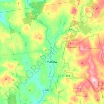
Name: Marlow topographic map, elevation, terrain.
Location: Marlow, Cheshire County, New Hampshire, 03456, United States (43.07082 -72.26247 43.18169 -72.15665)
Average elevation: 446 m
Minimum elevation: 305 m
Maximum elevation: 648 m
Make a donation
Gear up for your next adventure:
As an Amazon Associate, this site earns from qualifying purchases at no extra cost to you.
Other topographic maps
Click on a map to view its topography, its elevation and its terrain.
Stone Pond
United States > New Hampshire > Cheshire County > Marlow > Gee Mill
Average elevation: 430 m
Mount Monadnock
United States > New Hampshire > Cheshire County > Jaffrey
From the base to the summit, floral species diminish with increasingly shallow soil levels. The summit is home to many different specialized sub-alpine species which can retain moisture for long periods of time. Alpine and sub-alpine species include mountain ash, cotton grass, sheep laurel, mountain sandwort,…
Average elevation: 687 m
Make a donation
Gear up for your next adventure:
As an Amazon Associate, this site earns from qualifying purchases at no extra cost to you.
Camp Notre Dame
United States > New Hampshire > Cheshire County > Chesterfield
Average elevation: 223 m
Mount Monadnock
United States > New Hampshire > Cheshire County > Jaffrey
From the base to the summit, floral species diminish with increasingly shallow soil levels. The summit is home to many different specialized sub-alpine species which can retain moisture for long periods of time. Alpine and sub-alpine species include mountain ash, cotton grass, sheep laurel, mountain sandwort,…
Average elevation: 687 m
Make a donation
Gear up for your next adventure:
As an Amazon Associate, this site earns from qualifying purchases at no extra cost to you.
Mount Monadnock
United States > New Hampshire > Cheshire County > Jaffrey
From the base to the summit, floral species diminish with increasingly shallow soil levels. The summit is home to many different specialized sub-alpine species which can retain moisture for long periods of time. Alpine and sub-alpine species include mountain ash, cotton grass, sheep laurel, mountain sandwort,…
Average elevation: 687 m
Gilboa Mountain
United States > New Hampshire > Cheshire County > Westmoreland
Average elevation: 331 m
West Chesterfield
United States > New Hampshire > Cheshire County > Chesterfield
Average elevation: 168 m
Make a donation
Gear up for your next adventure:
As an Amazon Associate, this site earns from qualifying purchases at no extra cost to you.