Geolocate

Seoni topographic map

Click on the map to display elevation.

About this map

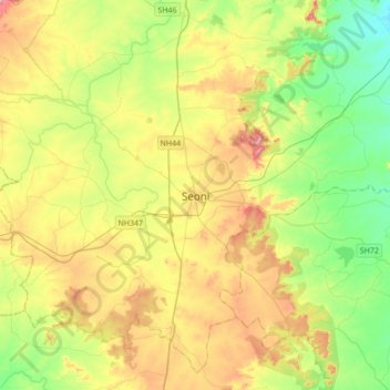
Name: Seoni topographic map, elevation, terrain.

Location: Seoni, Seoni Tahsil, Seoni, Madhya Pradesh, 480600, India (21.93100 79.39078 22.25100 79.71078)

Average elevation: 593 m

Minimum elevation: 490 m

Maximum elevation: 754 m

Other topographic maps

Click on a map to view its topography, its elevation and its terrain.

Khamariya

India > Madhya Pradesh > Seoni Tahsil > Seoni

Average elevation: 624 m

Manori

India > Madhya Pradesh > Seoni Tahsil

Average elevation: 660 m

Seoni Tahsil

India > Madhya Pradesh > Seoni Tahsil

Average elevation: 578 m

Gear up for your next adventure:

☀️Portable Solar Chargers - High-efficiency panels to hang on your backpack while walking
🌬️Windbreaker Jackets - Wind protection jackets
🗺️Topographic Maps - Detailed maps for hiking and navigation
🛌Compact Down Sleeping Bags - Warmth without the bulk, ideal for backcountry camping
🧣Merino Neck Gaiters - Versatile headwear for warmth, sun protection, or dust filtering

As an Amazon Associate, this site earns from qualifying purchases at no extra cost to you.