Geolocate

Weesp topographic map

Click on the map to display elevation.

About this map

Name: Weesp topographic map, elevation, terrain.

Location: Weesp, North Holland, Netherlands (52.27798 5.01727 52.33087 5.10769)

Average elevation: -1 m

Minimum elevation: -6 m

Maximum elevation: 5 m

Other topographic maps

Click on a map to view its topography, its elevation and its terrain.
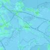
Weesp

Netherlands > North Holland > Weesp

Average elevation: 0 m

Gear up for your next adventure:

⌚Altimeter Watches - Watches with altitude tracking
🩹Blister Prevention Tape - Apply to friction points before they become painful sores
☀️Portable Solar Chargers - High-efficiency panels to hang on your backpack while walking
🧣Merino Neck Gaiters - Versatile headwear for warmth, sun protection, or dust filtering
🔭Compact Hiking Binoculars - Lightweight optics for scouting routes or birdwatching

As an Amazon Associate, this site earns from qualifying purchases at no extra cost to you.