
Ain Sfa topographic map
Interactive map
Click on the map to display elevation.
About this map
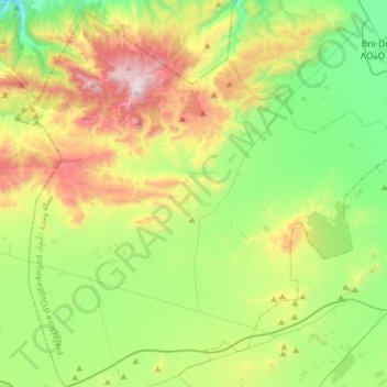
Name: Ain Sfa topographic map, elevation, terrain.
Average elevation: 703 m
Minimum elevation: 296 m
Maximum elevation: 1,516 m
Other topographic maps
Click on a map to view its topography, its elevation and its terrain.
Aïn Almou
Maroc > cercle d'Oujda-Banlieue nord > Ain Sfa
Aïn Almou, Ain Sfa, caïdat d'Aïn Sfa, cercle d'Oujda-Banlieue nord, Préfecture d'Oujda-Angad, Oriental, Maroc
Average elevation: 1,285 m