
Rain Forest topographic map
Interactive map
Click on the map to display elevation.
About this map
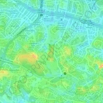
Name: Rain Forest topographic map, elevation, terrain.
Location: Rain Forest, Tanglin, Singapore, Central, 259569, Singapore (1.31100 103.81524 1.31501 103.81718)
Average elevation: 22 m
Minimum elevation: 2 m
Maximum elevation: 62 m
Other topographic maps
Click on a map to view its topography, its elevation and its terrain.
Dhoby Ghaut Green
Singapore > Central > Singapore
Dhoby Ghaut Green, Museum, Singapore, Central, 238826, Singapore
Average elevation: 19 m
Singapore Botanic Gardens
Singapore > Central > Singapore
Singapore Botanic Gardens, Tanglin, Singapore, Central, 259569, Singapore
Average elevation: 22 m