
Le Guirou topographic map
Interactive map
Click on the map to display elevation.
About this map
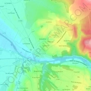
Name: Le Guirou topographic map, elevation, terrain.
Average elevation: 138 m
Minimum elevation: 93 m
Maximum elevation: 224 m
Other topographic maps
Click on a map to view its topography, its elevation and its terrain.
La Fontaine
France > Occitanie > Tarn-et-Garonne > Montricoux
La Fontaine, Montricoux, Montauban, Tarn-et-Garonne, Occitanie, France métropolitaine, 82800, France
Average elevation: 124 m