
Make a donation
Gear up for your next adventure:
As an Amazon Associate, this site earns from qualifying purchases at no extra cost to you.
Turkmenabat City topographic map
Click on the map to display elevation.
Make a donation
Gear up for your next adventure:
As an Amazon Associate, this site earns from qualifying purchases at no extra cost to you.
Turkmenabat City
Türkmenabat is located at an altitude of 187 m (614 ft) on the banks of the Amu Darya River, near the border with Uzbekistan. Türkmenabat is at the center of Lebap province, which has borders with three provinces in Turkmenistan: Mary, Ahal and Daşoguz. The province also borders Uzbekistan and Afghanistan.
Make a donation
Gear up for your next adventure:
As an Amazon Associate, this site earns from qualifying purchases at no extra cost to you.
About this map
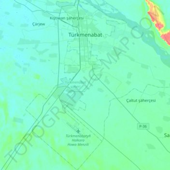
Name: Turkmenabat City topographic map, elevation, terrain.
Location: Turkmenabat City, Lebap Region, 746100, Turkmenistan (38.87157 63.46845 39.12438 63.66250)
Average elevation: 194 m
Minimum elevation: 185 m
Maximum elevation: 259 m
Make a donation
Gear up for your next adventure:
As an Amazon Associate, this site earns from qualifying purchases at no extra cost to you.