
Make a donation
Gear up for your next adventure:
As an Amazon Associate, this site earns from qualifying purchases at no extra cost to you.
Valence topographic map
Click on the map to display elevation.
Make a donation
Gear up for your next adventure:
As an Amazon Associate, this site earns from qualifying purchases at no extra cost to you.
Valence
The area of the commune is 3,669 hectares (9,070 acres), representing 36.69 square kilometres (14.17 sq mi); the altitude varies between 106–191 metres (348–627 ft).
Make a donation
Gear up for your next adventure:
As an Amazon Associate, this site earns from qualifying purchases at no extra cost to you.
About this map
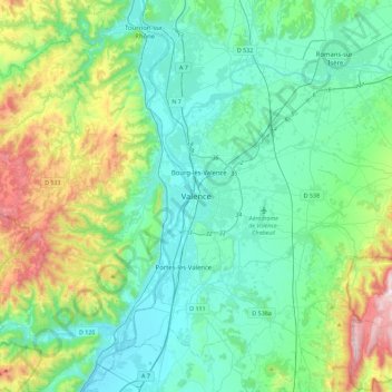
Name: Valence topographic map, elevation, terrain.
Average elevation: 287 m
Minimum elevation: 87 m
Maximum elevation: 996 m
Make a donation
Gear up for your next adventure:
As an Amazon Associate, this site earns from qualifying purchases at no extra cost to you.
Other topographic maps
Click on a map to view its topography, its elevation and its terrain.
Valence
France > Auvergne-Rhône-Alpes > Drôme
The area of the commune is 3,669 hectares (9,070 acres), representing 36.69 square kilometres (14.17 sq mi); the altitude varies between 106–191 metres (348–627 ft).
Average elevation: 151 m