
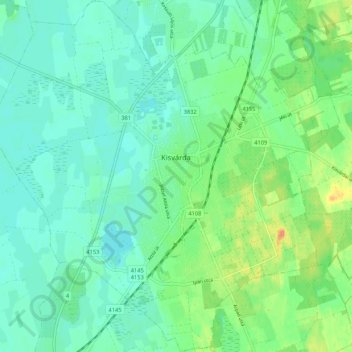
Kleinwardein topographic map
Interactive map
Click on the map to display elevation.
About this map
Name: Kleinwardein topographic map, elevation, terrain.
Average elevation: 103 m
Minimum elevation: 92 m
Maximum elevation: 129 m
Other topographic maps
Click on a map to view its topography, its elevation and its terrain.
Mátészalkai járás
Ungarn > Komitat Saboltsch-Sathmar-Berg
Mátészalkai járás, Komitat Saboltsch-Sathmar-Berg, Nördliche Tiefebene, Nördliche Große Tiefebene, Ungarn
Average elevation: 125 m
Nyírmeggyes
Ungarn > Komitat Saboltsch-Sathmar-Berg > Nyírmeggyes
Nyírmeggyes, Mátészalkai járás, Komitat Saboltsch-Sathmar-Berg, Nördliche Große Tiefebene, 4722, Ungarn
Average elevation: 139 m
Olcsvaapáti
Ungarn > Komitat Saboltsch-Sathmar-Berg > Olcsvaapáti
Olcsvaapáti, Fehérgyarmati járás, Komitat Saboltsch-Sathmar-Berg, Nördliche Große Tiefebene, 4914, Ungarn
Average elevation: 110 m
Mérk
Ungarn > Komitat Saboltsch-Sathmar-Berg
Mérk, Mátészalkai járás, Komitat Saboltsch-Sathmar-Berg, Nördliche Tiefebene, Nördliche Große Tiefebene, 4352, Ungarn
Average elevation: 119 m
Záhony
Ungarn > Komitat Saboltsch-Sathmar-Berg
Záhony, Záhonyi járás, Komitat Saboltsch-Sathmar-Berg, Nördliche Tiefebene, Nördliche Große Tiefebene, 4625, Ungarn
Average elevation: 105 m