Geolocate

Fiorano Modenese topographic map

Click on the map to display elevation.

About this map
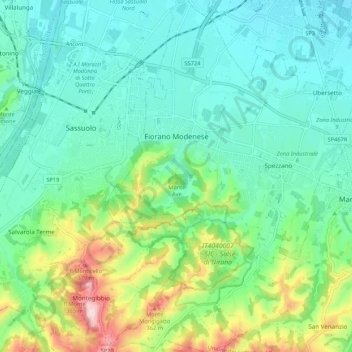
Name: Fiorano Modenese topographic map, elevation, terrain.

Location: Fiorano Modenese, Unione dei comuni del Distretto Ceramico, Modena, Emilia-Romagna, 41042, Italy (44.49251 10.79101 44.56854 10.86597)

Average elevation: 168 m

Minimum elevation: 79 m

Maximum elevation: 430 m

Other topographic maps

Click on a map to view its topography, its elevation and its terrain.
Bell'Italia

Italy > Emilia-Romagna > Modena > Maranello

Average elevation: 117 m

Gear up for your next adventure:

🧦Hiking Socks - Comfortable socks for long hikes
🧣Merino Neck Gaiters - Versatile headwear for warmth, sun protection, or dust filtering
🧰Survival Kits - Essential survival gear
💡Collapsible Camping Lanterns - Illuminate your base camp or tent for map studying at night
🏃Compression Recovery Socks - Reduce leg fatigue after heavy days of elevation gain

As an Amazon Associate, this site earns from qualifying purchases at no extra cost to you.