
Garvão topographic map
Interactive map
Click on the map to display elevation.
About this map
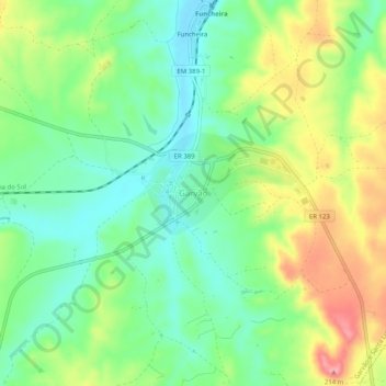
Name: Garvão topographic map, elevation, terrain.
Location: Garvão, Ourique, Beja, 7670-135, Portugal (37.68782 -8.36050 37.72782 -8.32050)
Average elevation: 141 m
Minimum elevation: 98 m
Maximum elevation: 210 m
Other topographic maps
Click on a map to view its topography, its elevation and its terrain.
Pereirinho
Portugal > Beja > Ourique > Santana da Serra
Pereirinho, Santana da Serra, Ourique, Beja, 7670-614, Portugal
Average elevation: 270 m