
Make a donation
Gear up for your next adventure:
As an Amazon Associate, this site earns from qualifying purchases at no extra cost to you.
Tadipatri topographic map
Click on the map to display elevation.
Make a donation
Gear up for your next adventure:
As an Amazon Associate, this site earns from qualifying purchases at no extra cost to you.
Tadipatri
Tadipatri is located at 14°55′N 78°01′E / 14.92°N 78.02°E / 14.92; 78.02. Its average elevation is 223 metres or 731 feet. Tadipatri lies on the southern bank of Pennar River. Due to Mid Pennar Dam constructed upstream, the section of river in Tadipatri is usually dry throughout the year. Tadipatri is rich in cement grade limestone deposits. The limestone reserves are extending in a triangle from Tadipatri in Anantapur district to Kamalapuram in Kadapa district and Bethamcherla in Kurnool district.
Make a donation
Gear up for your next adventure:
As an Amazon Associate, this site earns from qualifying purchases at no extra cost to you.
About this map
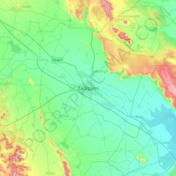
Name: Tadipatri topographic map, elevation, terrain.
Location: Tadipatri, Tadpatri, Anantapur, Andhra Pradesh, 515400, India (14.74696 77.84971 15.06696 78.16971)
Average elevation: 273 m
Minimum elevation: 206 m
Maximum elevation: 491 m
Make a donation
Gear up for your next adventure:
As an Amazon Associate, this site earns from qualifying purchases at no extra cost to you.