
Make a donation
Gear up for your next adventure:
As an Amazon Associate, this site earns from qualifying purchases at no extra cost to you.
Štrba topographic map
Click on the map to display elevation.
Make a donation
Gear up for your next adventure:
As an Amazon Associate, this site earns from qualifying purchases at no extra cost to you.
Štrba
The municipality lies at an altitude of 829 metres and covers an area of 43.463 km2. It has a population of 3,653 people. Its detached borough of Tatranská Štrba hosts the Štrba railway station, the valley terminus of the Štrbské Pleso–Štrba rack railway, and a stop on one of Slovakia's major railways. The mountain resort settlement of Štrbské Pleso also belongs to the village.
Make a donation
Gear up for your next adventure:
As an Amazon Associate, this site earns from qualifying purchases at no extra cost to you.
About this map
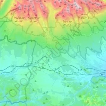
Name: Štrba topographic map, elevation, terrain.
Location: Štrba, District of Poprad, Region of Prešov, Slovakia (49.00910 20.01286 49.17239 20.11123)
Average elevation: 1,134 m
Minimum elevation: 725 m
Maximum elevation: 2,617 m
Make a donation
Gear up for your next adventure:
As an Amazon Associate, this site earns from qualifying purchases at no extra cost to you.
Other topographic maps
Click on a map to view its topography, its elevation and its terrain.