
Valentine topographic map
Interactive map
Click on the map to display elevation.
About this map
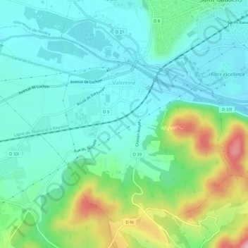
Name: Valentine topographic map, elevation, terrain.
Average elevation: 408 m
Minimum elevation: 354 m
Maximum elevation: 563 m
Other topographic maps
Click on a map to view its topography, its elevation and its terrain.
Revel
France > Occitania > Haute-Garonne
Revel, Toulouse, Haute-Garonne, Occitania, Metropolitan France, 31250, France
Average elevation: 239 m
Mall Barrat
France > Occitania > Haute-Garonne > Castillon-de-Larboust
Mall Barrat, Castillon-de-Larboust, Saint-Gaudens, Haute-Garonne, Occitania, Metropolitan France, 31110, France
Average elevation: 2,542 m
Luchon-Superbagnères
France > Occitania > Haute-Garonne > Saint-Aventin > Luchon-Superbagnères
Luchon-Superbagnères, Saint-Aventin, Saint-Gaudens, Haute-Garonne, Occitania, Metropolitan France, 31110, France
Average elevation: 1,331 m
Bagnères-de-Luchon
France > Occitania > Haute-Garonne > Bagnères-de-Luchon
Bagnères-de-Luchon, Saint-Gaudens, Haute-Garonne, Occitania, Metropolitan France, 31110, France
Average elevation: 1,666 m