
VII. Bezirk topographic map
Interactive map
Click on the map to display elevation.
About this map
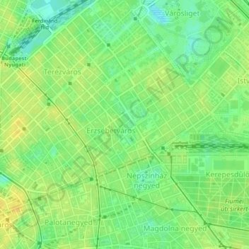
Name: VII. Bezirk topographic map, elevation, terrain.
Location: VII. Bezirk, Budapest, Mittelungarn, Ungarn (47.49436 19.05516 47.51122 19.09114)
Average elevation: 115 m
Minimum elevation: 102 m
Maximum elevation: 125 m
Other topographic maps
Click on a map to view its topography, its elevation and its terrain.
Gellértberg
Gellértberg, Budapest, XI. Bezirk, Mittelungarn, 1114, Ungarn
Average elevation: 126 m
Gottesberg
Gottesberg, XII. Bezirk, Budapest, XII. Bezirk, Mittelungarn, 1125, Ungarn
Average elevation: 247 m
Johannisberg
Johannisberg, XII. Bezirk, Budapest, Mittelungarn, 1021, Ungarn
Average elevation: 343 m
Galgenberg
Galgenberg, XI. Bezirk, Budapest, Mittelungarn, Ungarn
Average elevation: 130 m
Johannisberg
Johannisberg, XII. Bezirk, Budapest, Mittelungarn, Ungarn
Average elevation: 333 m