
Gándara topographic map
Interactive map
Click on the map to display elevation.
About this map
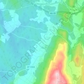
Name: Gándara topographic map, elevation, terrain.
Average elevation: 263 m
Minimum elevation: 189 m
Maximum elevation: 554 m
Other topographic maps
Click on a map to view its topography, its elevation and its terrain.
Camariñas
España > Galicia > Tierra de Soneira
Camariñas, Tierra de Soneira, La Coruña, Galicia, 15123, España
Average elevation: 33 m