
Thank you for supporting this site ❤️
Make a donation
Make a donation
Gear up for your next adventure:
As an Amazon Associate, this site earns from qualifying purchases at no extra cost to you.
Tomacaya topographic map
Click on the map to display elevation.
Thank you for supporting this site ❤️
Make a donation
Make a donation
Gear up for your next adventure:
As an Amazon Associate, this site earns from qualifying purchases at no extra cost to you.
About this map
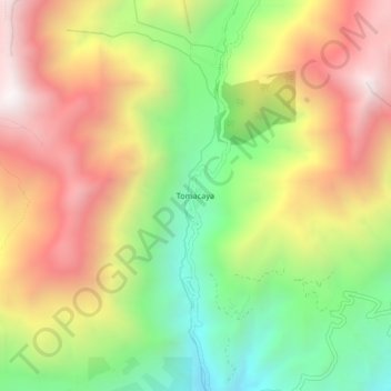
Name: Tomacaya topographic map, elevation, terrain.
Location: Tomacaya, Limatambo, Province of Anta, Cusco, Peru (-13.45721 -72.46353 -13.41721 -72.42353)
Average elevation: 3,394 m
Minimum elevation: 2,750 m
Maximum elevation: 4,066 m
Thank you for supporting this site ❤️
Make a donation
Make a donation
Gear up for your next adventure:
As an Amazon Associate, this site earns from qualifying purchases at no extra cost to you.