
Rochehaut topographic map
Interactive map
Click on the map to display elevation.
About this map
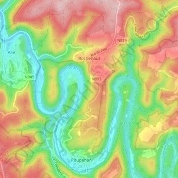
Name: Rochehaut topographic map, elevation, terrain.
Location: Rochehaut, Bouillon, Neufchâteau, Luxemburg, Wallonië, België (49.80637 4.97086 49.85692 5.02732)
Average elevation: 298 m
Minimum elevation: 182 m
Maximum elevation: 431 m
Other topographic maps
Click on a map to view its topography, its elevation and its terrain.
Corbion
België > Luxemburg > Neufchâteau > Bouillon
Corbion, Bouillon, Neufchâteau, Luxemburg, Wallonië, 6838, België
Average elevation: 344 m
Noirefontaine
België > Luxemburg > Neufchâteau > Bouillon > Noirefontaine
Noirefontaine, Bouillon, Neufchâteau, Luxemburg, Wallonië, 6831, België
Average elevation: 331 m
Dohan
België > Luxemburg > Neufchâteau > Bouillon
Dohan, Bouillon, Neufchâteau, Luxemburg, Wallonië, België
Average elevation: 284 m
Poupehan
België > Luxemburg > Neufchâteau > Bouillon
Poupehan, Bouillon, Neufchâteau, Luxemburg, Wallonië, België
Average elevation: 270 m