
Kabul District topographic map
Interactive map
Click on the map to display elevation.
About this map
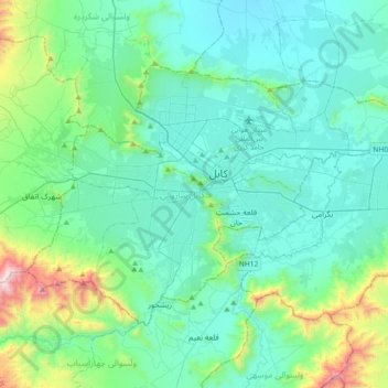
Name: Kabul District topographic map, elevation, terrain.
Location: Kabul District, Kabul Province, Afghanistan (34.42502 68.97846 34.61048 69.36165)
Average elevation: 1,974 m
Minimum elevation: 1,716 m
Maximum elevation: 3,196 m
Other topographic maps
Click on a map to view its topography, its elevation and its terrain.
Kabul
Afghanistan > Kabul Province > Kabul District
The modern-day city of Kabul is located high up in a narrow valley in the Hindu Kush, and is bounded by the Kabul River. At an elevation of 1,790 metres (5,873 ft), it is one of the highest capital cities in the world. The center of this city includes its old neighborhoods, which include the areas of Khashti…
Average elevation: 1,945 m