
Uyuni topographic map
Interactive map
Click on the map to display elevation.
About this map
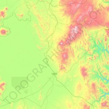
Name: Uyuni topographic map, elevation, terrain.
Location: Uyuni, Antonio Quijarro, Potosí, Bolivie (-20.99074 -67.27036 -19.35550 -66.18732)
Average elevation: 3,884 m
Minimum elevation: 3,229 m
Maximum elevation: 5,517 m
La ville d'Uyuni est sise à une altitude de 3 670 m et se trouve à la jonction d'un plateau étendu à l'ouest et de territoires montagneux de la Cordillère plus à l'est.
Other topographic maps
Click on a map to view its topography, its elevation and its terrain.
Pulacayo
Bolivie > Potosí > Antonio Quijarro > Uyuni
Pulacayo, Uyuni, Antonio Quijarro, Potosí, Bolivie
Average elevation: 4,194 m