
Thank you for supporting this site ❤️
Make a donation
Make a donation
Gear up for your next adventure:
As an Amazon Associate, this site earns from qualifying purchases at no extra cost to you.
Wembdon topographic map
Click on the map to display elevation.
Thank you for supporting this site ❤️
Make a donation
Make a donation
Gear up for your next adventure:
As an Amazon Associate, this site earns from qualifying purchases at no extra cost to you.
About this map
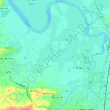
Name: Wembdon topographic map, elevation, terrain.
Location: Wembdon, Chilton Trinity, Somerset, England, United Kingdom (51.12811 -3.04996 51.17709 -3.00197)
Average elevation: 9 m
Minimum elevation: -8 m
Maximum elevation: 48 m
Thank you for supporting this site ❤️
Make a donation
Make a donation
Gear up for your next adventure:
As an Amazon Associate, this site earns from qualifying purchases at no extra cost to you.