
Area F (Kokanee Range) topographic map
Interactive map
Click on the map to display elevation.
About this map
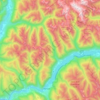
Name: Area F (Kokanee Range) topographic map, elevation, terrain.
Average elevation: 1,463 m
Minimum elevation: 499 m
Maximum elevation: 2,772 m
Other topographic maps
Click on a map to view its topography, its elevation and its terrain.
Poplar Creek
Canada > British Columbia > Regional District of Central Kootenay > Area D (Lardeau Valley/Duncan Lake)
Average elevation: 1,732 m
Stoney Creek
Canada > British Columbia > Regional District of Central Kootenay > Area K (The Arrow Lakes)
Average elevation: 1,295 m
Whitewater Mountain
Canada > British Columbia > Regional District of Central Kootenay > Area H (The Slocan Valley)
Average elevation: 2,245 m
Mount Cooper
Canada > British Columbia > Regional District of Central Kootenay > Area D (Lardeau Valley/Duncan Lake)
Average elevation: 2,480 m