
Make a donation
Gear up for your next adventure:
As an Amazon Associate, this site earns from qualifying purchases at no extra cost to you.
Vista Hermosa topographic map
Click on the map to display elevation.
Make a donation
Gear up for your next adventure:
As an Amazon Associate, this site earns from qualifying purchases at no extra cost to you.
About this map
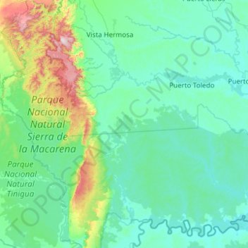
Name: Vista Hermosa topographic map, elevation, terrain.
Location: Vista Hermosa, Ariari, Meta, RAP (Especial) Central, Colombia (2.32209 -74.05671 3.21680 -73.06963)
Average elevation: 353 m
Minimum elevation: 192 m
Maximum elevation: 1,590 m
Make a donation
Gear up for your next adventure:
As an Amazon Associate, this site earns from qualifying purchases at no extra cost to you.
Other topographic maps
Click on a map to view its topography, its elevation and its terrain.
Restrepo
Los doctores Miguel Abadía Méndez y Marco Tulio Vergara Rey exiliados políticos, organizaron sus respectivos Hatos Guayabal y el Caibe. Don Roberto Rodríguez quien sucedió al primer administrador de Salinas trabajó intensamente por la estabilización y adelanto del naciente municipio que ya fue conocido…
Average elevation: 553 m