
Traunsee topographic map
Interactive map
Click on the map to display elevation.
About this map
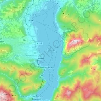
Name: Traunsee topographic map, elevation, terrain.
Average elevation: 729 m
Minimum elevation: 417 m
Maximum elevation: 1,645 m
Other topographic maps
Click on a map to view its topography, its elevation and its terrain.
Traunkirchen
Österreich > Oberösterreich > Traunkirchen
Traunkirchen, Bezirk Gmunden, Oberösterreich, 4801, Österreich
Average elevation: 669 m