Geolocate

Sequoia National Park topographic map

Interactive map

Click on the map to display elevation.

Sequoia National Park

Many park visitors enter Sequoia National Park through its southern entrance near the town of Three Rivers at Ash Mountain at 1,700 ft (520 m) elevation. The lower elevations around Ash Mountain contain the only National Park Service-protected California Foothills ecosystem, consisting of blue oak woodlands, foothills chaparral, grasslands, yucca plants, and steep, mild river valleys. Seasonal weather results in a changing landscape throughout the foothills with hot summer yielding an arid landscape while spring and winter rains result in blossoming wildflowers and lush greens. The region is also home to abundant wildlife: bobcats, foxes, ground squirrels, rattlesnakes, and mule deer are commonly seen in this area, and more rarely, reclusive mountain lions and the Pacific fisher are seen as well. The last California grizzly was killed in this park in 1922 (at Horse Corral Meadow). The California Black Oak is a key transition species between the chaparral and higher elevation conifer forest.

Wikipedia (CC-BY-SA 3.0)

About this map

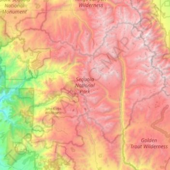
Name: Sequoia National Park topographic map, elevation, terrain.

Location: Sequoia National Park, Tulare County, California, 93262, United States (36.29108 -118.91954 36.70066 -118.23495)

Average elevation: 2,515 m

Minimum elevation: 265 m

Maximum elevation: 4,401 m

Other topographic maps

Click on a map to view its topography, its elevation and its terrain.

Sierra Nevada

United States > California > Tulare County

Average elevation: 3,888 m

Forester Pass

United States > California > Tulare County

Average elevation: 3,855 m

Durrwood Camp

United States > California > Tulare County

Average elevation: 1,527 m

Anderson Point

United States > California > Tulare County

Average elevation: 2,498 m

Johnsondale

United States > California > Tulare County

Average elevation: 1,565 m

Mount Whitney

United States > California > Tulare County

Mount Whitney (Paiute: Too-man-i-goo-yah or Too-man-go-yah) is the highest mountain in the contiguous United States, with an elevation of 14,505 feet (4,421 m). It is in East–Central California, in the Sierra Nevada, on the boundary between California's Inyo and Tulare counties, and 84.6 miles (136.2 km)…

Average elevation: 3,903 m

Nine Lake Basin

United States > California > Tulare County

Average elevation: 3,440 m

Sierra Nevada

United States > California > Tulare County

Average elevation: 3,888 m

Mount Whitney

United States > California > Tulare County

Mount Whitney (Paiute: Tumanguya; Too-man-i-goo-yah) is the highest mountain in the contiguous United States and the Sierra Nevada, with an elevation of 14,505 feet (4,421 m). It is in East–Central California, on the boundary between California's Inyo and Tulare counties, 84.6 miles (136.2 km) west-northwest…

Average elevation: 3,903 m

Red Fir

United States > California > Tulare County

Average elevation: 2,131 m

Badger

United States > California > Tulare County

Average elevation: 927 m

Ultra

United States > California > Tulare County

Average elevation: 166 m

Mount Keith

United States > California > Tulare County

Average elevation: 3,702 m

Allensworth

United States > California > Tulare County

Allensworth sits at an elevation of 213 feet (65 m), the same elevation as the huge and historically important Tulare Lake shore when it was full. The community is located in the ZIP Code 93219 and in the area code 661.

Average elevation: 63 m

Camp Nelson

United States > California > Tulare County

Average elevation: 1,649 m

Crescent Meadow

United States > California > Tulare County

Average elevation: 2,007 m

Silver City

United States > California > Tulare County

Average elevation: 2,353 m

Mount Whitney

United States > California > Tulare County

Mount Whitney (Paiute: Tumanguya; Too-man-i-goo-yah) is the highest mountain in the contiguous United States and the Sierra Nevada, with an elevation of 14,505 feet (4,421 m). It is in East–Central California, on the boundary between California's Inyo and Tulare counties, 84.6 miles (136.2 km) west-northwest…

Average elevation: 3,903 m

Ponderosa

United States > California > Tulare County

Average elevation: 2,222 m

Moro Rock

United States > California > Tulare County

Average elevation: 1,628 m

Ponderosa

United States > California > Tulare County

Average elevation: 2,222 m