
Thank you for supporting this site ❤️
Make a donation
Make a donation
Gear up for your next adventure:
As an Amazon Associate, this site earns from qualifying purchases at no extra cost to you.
Dorda topographic map
Click on the map to display elevation.
Thank you for supporting this site ❤️
Make a donation
Make a donation
Gear up for your next adventure:
As an Amazon Associate, this site earns from qualifying purchases at no extra cost to you.
About this map
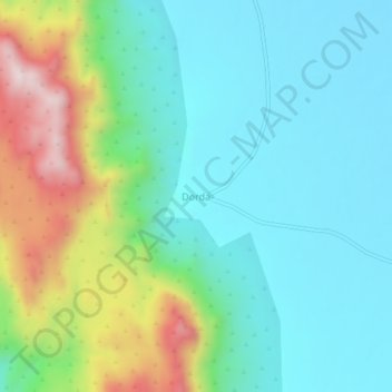
Name: Dorda topographic map, elevation, terrain.
Location: Dorda, Jaswantpura Tehsil, Jalore, Rajasthan, India (24.87099 72.40737 24.91099 72.44737)
Average elevation: 392 m
Minimum elevation: 224 m
Maximum elevation: 849 m
Thank you for supporting this site ❤️
Make a donation
Make a donation
Gear up for your next adventure:
⌚Altimeter Barometer Watches - Outdoor watches with built-in sensors to track altitude changes and weather shifts
As an Amazon Associate, this site earns from qualifying purchases at no extra cost to you.