Geolocate

Clifton topographic map

Click on the map to display elevation.

About this map

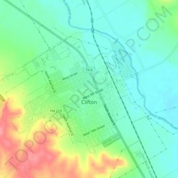
Name: Clifton topographic map, elevation, terrain.

Location: Clifton, Bosque County, Texas, 76634, United States (31.76906 -97.61033 31.79658 -97.56560)

Average elevation: 218 m

Minimum elevation: 188 m

Maximum elevation: 280 m

Other topographic maps

Click on a map to view its topography, its elevation and its terrain.

Cayote

United States > Texas > Bosque County

Average elevation: 225 m

Kopperl

United States > Texas > Bosque County

Average elevation: 176 m

Laguna Park

United States > Texas > Bosque County

Average elevation: 175 m

Mosheim

United States > Texas > Bosque County

Average elevation: 286 m

Gear up for your next adventure:

🥶Thermal Beanies - Warm hats for cold hikes
🕯️Emergency Whistles - Safety whistles for hiking
💧Personal Water Filters - Drink safely from streams and lakes identified on your map
🛌Compact Down Sleeping Bags - Warmth without the bulk, ideal for backcountry camping
🔪Outdoor Multi-tools - Versatile tools for gear repair and survival tasks in the wilderness

As an Amazon Associate, this site earns from qualifying purchases at no extra cost to you.