Geolocate

Ha'il topographic map

Click on the map to display elevation.

About this map
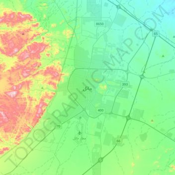
Name: Ha'il topographic map, elevation, terrain.

Location: Ha'il, Hail, Ḥa'il Province, 55421, Saudi Arabia (27.36087 41.53860 27.68087 41.85860)

Average elevation: 1,050 m

Minimum elevation: 888 m

Maximum elevation: 1,533 m

Other topographic maps

Click on a map to view its topography, its elevation and its terrain.

Baqa

Saudi Arabia > Ḥa'il Province

Average elevation: 695 m

Hail

Saudi Arabia > Ḥa'il Province

Average elevation: 936 m

Baqa

Saudi Arabia > Ḥa'il Province

Average elevation: 695 m

Arkan

Saudi Arabia > Ḥa'il Province

Average elevation: 1,042 m

Mawqaq

Saudi Arabia > Ḥa'il Province

Average elevation: 1,009 m

Al Dhahira

Saudi Arabia > Ḥa'il Province > Baqa

Average elevation: 695 m

Ash Shinan

Saudi Arabia > Ḥa'il Province

Average elevation: 869 m

Gear up for your next adventure:

🧺Fast-Dry Microfiber Towels - Large towels that pack down to the size of an orange
🔋Solar Power Banks - Solar chargers for outdoors
🧭Compass - Navigation compasses for outdoor exploration
🔭Compact Hiking Binoculars - Lightweight optics for scouting routes or birdwatching
🥾Hiking Shoes - Lightweight hiking shoes for day hikes

As an Amazon Associate, this site earns from qualifying purchases at no extra cost to you.